Trekking Route 4: The Eren Dağı Summit Climb
The Story of the Route
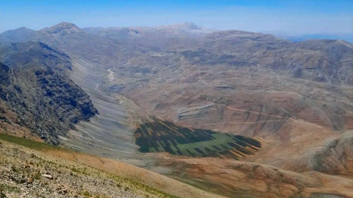
This is more than a hike; it is a journey to the highest point in the Seydikemer region, a challenge, and a salute to the summit. You will climb to the 2863-meter peak of Mount Eren, a vantage point that lays a vast geography at your feet, from the turquoise waters of the Mediterranean to the endless chains of the Taurus Mountains. This route offers you the chance to see the ancient cities and fertile plains of Lycia, this time through the eyes of an eagle. You will witness the flora and climate change layer by layer along the path, and once you cross the tree line and reach the alpine meadows, you will find yourself in another world. The silence at the summit, the whisper of the wind, and that incredible feeling of accomplishment will be worth every moment of this challenging climb.
Practical Information
| Feature | Detail |
|---|---|
| Difficulty Level | HARD (High altitude, steep ascent, requires experience) |
| Distance | Approx. 10 - 12 km (6.2 - 7.5 miles) (Round Trip) |
| Estimated Time | 6 - 8 hours |
| Starting/Finishing Point | Seki Plateau, the highest point accessible by vehicle at the old Eren Dağı Ski Center |
| Best Season | Summer (Late June - Early September). Winter and spring climbs are dangerous. |
| Water Sources | There are no water sources on the route. At least 3 liters of water per person must be carried. |
| Terrain | Forest road, distinct mountain path, rocky and scree-covered ground. |
Step-by-Step Route
- The Start: From Seki Plateau, drive up to the area of the old ski center facilities. The hike begins from where you park your vehicle, following the clear path that aims for the summit.
- Crossing the Treeline: The first part of the route offers a gradual ascent up to the tree line. After this section, the view opens up completely, and you find yourself in an alpine landscape.
- Ascent Along the Ridge: The path generally follows one of the mountain's ridges, ascending with a constant gradient towards the peak. Views of the Eşen Plain and Girdev Lake will accompany you in this section.
- The Final Push to the Summit: The last part of the climb can become rockier and steeper. Gather your motivation when the summit structure comes into view and take the final steps.
- Summit and Return: A 360-degree panorama will greet you at the 2863-meter summit. The Gulf of Fethiye, Patara beach, the silhouette of Kaş, and the vastness of the Taurus Mountains... After enjoying the view, begin your descent. The descent requires as much concentration as the ascent. The return is via the same route.
- Sense of Accomplishment: The personal satisfaction of reaching the highest point in the region.
- Unparalleled Panorama: An indescribable view stretching from the Mediterranean to the inner Taurus Mountains.
- Alpine Nature: Flora specific to high altitudes and cool, clean mountain air.
- Isolation: The experience of being in the heart of nature, completely away from civilization.
Route Highlights
Tips
This route is absolutely not suitable for beginners. Good physical condition, mountain hiking experience, and basic navigation skills are required. Make sure you have a GPS device or an app with the route loaded. Mountain weather can change in an instant; a day that starts sunny can turn into a storm. Therefore, layered clothing, a waterproof and windproof jacket are essential. You must start the climb very early in the morning and never go alone. A hat, sunglasses, and high-factor sunscreen are lifesavers against sunburn at high altitudes.
Reviews
No reviews yet