Trekking Route: The Akdağ Uyluk Tepe Summit Climb
The Story of the Route
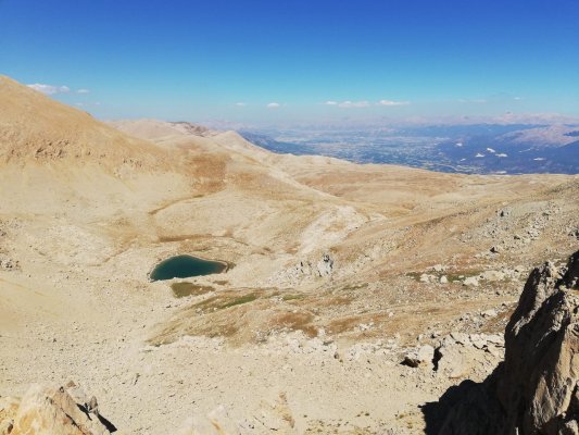
This is not a scenic walk; it is a serious mountaineering activity to one of the highest peaks of the Western Taurus Mountains. At 3024 meters, Uyluk Tepe is the roof of the Seydikemer and Kaş geography, and reaching this roof requires experience, endurance, and a deep respect for nature. This climb opens the doors to a completely different world, above the clouds, right next to the Mediterranean. During the journey, you will walk in an alpine geography above the tree line, where there are only rocks, endemic mountain flowers, and the sky. The sense of accomplishment you will feel upon reaching the summit and the 360-degree panorama laid out before you are powerful enough to make you forget all your fatigue. This is not just climbing a peak; it is experiencing the region's geography in its purest and wildest form.
Practical Information
| Feature | Detail |
|---|---|
| Difficulty Level | VERY HARD (Requires serious mountaineering experience, high fitness, and navigation skills) |
| Distance | Approx. 12 - 15 km (7.5 - 9.3 miles) (Round Trip) |
| Estimated Time | 8 - 10 hours |
| Starting Point | Usually Gömbe Plateau (Kaş) or the Yeşilgöl area |
| Best Season | Summer (July-August). Other times are dangerous due to snow and ice. |
| Water Sources | There are no water sources on the climbing route. At least 3-4 liters of water per person must be carried. |
| Terrain | Distinct mountain path, rocky, scree, and steep slopes. |
General Route Description
This climb should not be confused with other day hikes around Fethiye and should never be underestimated. The ascent usually begins from the Gömbe Plateau (part of Kaş district), driving up to Yeşilgöl (Green Lake), from where the trek starts. The route follows a distinct path with a continuous ascent on rocky and gravelly ground. As the altitude increases, the vegetation becomes sparse, and you find yourself in a completely alpine terrain. The final section near the summit is the steepest and most challenging part. This journey is not just a walk but a mountaineering activity that requires acclimatization to altitude and the ability to read weather conditions correctly. Therefore, it is strongly recommended that those who do not know the region very well undertake this climb only with a professional local guide.
During the climb, you may also have the opportunity to see other natural beauties of Akdağ, such as the famous Uçarsu Waterfall and Yeşilgöl. When you reach the summit, the view before you is incredible: the Gulf of Fethiye on one side, the islands of Kaş on the other, Girdev Lake and the Eşen Plain below... You feel as if you are looking at a map of the entire Lycian geography. To make this experience more comfortable, staying overnight at Gömbe Plateau to acclimatize is a good strategy.
Reviews
No reviews yet